Walks around Spetisbury
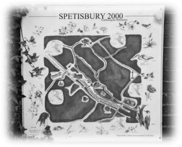 The starting point for all the walks is Marcia's Farm Shop at Clapcotts Farm, on the A350 on the northern edge of Spetisbury. Cars can be parked there. Provisions can be purchased at the shop. If not, a donation towards the upkeep of the car park would be appreciated. The Trailway also provides a useful focal point for a number of short walks around the village; these are described below, but can also be seen on the board "Spetisbury 2000" positioned at the top of the steps leading to the old railway station.
All Walks, of which there are five, are approximately 3 miles long and suitable for all the family (although not for push chairs, and stout, waterproof boots are recommended - especially after a spell of rain!). The walks are a combination of footpaths, bridleways and minor roads, and can be used by walkers along the whole walk and by horse riders and cyclists along those parts of the walk where marked. All the walks are signed; footpaths have yellow markers or may just say "footpath", while bridleways have blue markers, or a sign with the silhouette of a horse and rider.
Please follow the paths and observe the Country Code: leave no trace of your visit and take any litter home; leave gates and property as you find them; keep dogs under effective control, especially near sheep; and always consider other people enjoying the outdoors with you. The markers are maintained (voluntarily) by Mr Simon Lauder (01258 857343), who should be contacted with any comments / concerns over their positioning or visibility. Alternatively, contact the Parish Council Footpaths Officer, Neil Houghton (01258 857260).
Walks amended: N & S Houghton 2020
WALK 1 - Tarrant Abbey Circuit
Dog owners please clean up after your dog and use the bins provided.
After parking at Marcia's, walk away from the main road and follow the footpath signs over a long, raised metal footbridge which passes over the Mill House garden, walk alongside the Mill House, over the weir, follow the path and emerge through a small iron gate into the open water meadow.
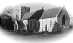 Go straight across the meadow (easterly), overa wide bridleway bridge and on through a metal gate and a second bridge just this side of Keynston Mill House. After passing the house, turn right, and keeping on the worn path between two fences follow the boundary until reaching an iron gate. Cross the minor road and follow the tarmac track, with Tarrant Abbey House on your right, until reaching St Mary The Virgin Church, Tarrant Crawford. This simple and evocative Church dates back to the 12th century, and is all that remains of a wealthy Cistercian nunnery - the 13th century Tarrant Abbey - to which it may have been a lay chapel.
With the church in front of you, turn right and then almost immediately left, through an iron gate. Follow the signed bridleway up the incline with the Abbey House on your right. Follow the path through the field at the top of the incline until you reach the minor road crossed earlier, again at an iron gate.
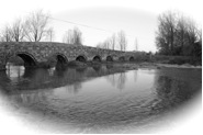 Cross the road into the field opposite, follow the bridleway through three gates, bearing left parallel to the river, to a further iron gate joining the minor road. Turning right, follow the road and cross over the beautiful Crawford Bridge (the bridge has a reset stone on the East side inscribed 1719, and was scheduled as a listed monument in 1955). Go straight over the A350, up Louse Lane, and join the start of the Trailway on your right. Follow the Trailway past Spetisbury Halt station, and continue until you pass under a bridge and pass the church on your right. You come to a slooping exit on the right by the school. Take this exit and turn right at the road passing the school back to the A350. Cross over and go back to Marcia's Farm Shop Car Park.
Approximate Distance: 3.5 miles
WALK 2 - North Farm Circuit
Dog owners please clean up after your dog and use the bins provided.
From Marcia's walk back to the road and cross the A350 walking straight ahead along the lane by the school. At the end of the school boundary turn left up the slope to the Trailway. At the top of the slope turn left along the Trailway. After approximately 200 meters turn right at the sign "FP10", and proceed over the wooden stile and then straight ahead with Home Plantation on your left. Go through a metal gate then diagonally across the field, passing houses on your right, to an iron gate at West End Lane, opposite the west end of the commercial watercress beds.
Turn left along the tarmacked lane for one mile until reaching North Farm on your left. Immediately before the farm buildings turn left and follow the footpath signst up a steep hill to the tall beech tree on the ridge due south of North Farm.
Stop and admire the view (in every direction!) then turn left at the tree and proceed along a chalky (and often rather muddy) path, passing Charlton Hill coppice on your left until reachingthe end of that track. Turn right then left keeping the hedgerow on your left, proceed straight on, keeping Home Plantation wood on your left, until you reach the stile onto the bridge over the Trailway. Cross over the bridge and turn back on yourself down the steps to the Trailway. Turn right under the bridge and pass the church on your right. You come to a sloping exit on the right by the school. Take this exit and turn right at the road passing the school back to the A350. Cross over and go back to Marcia's Farm Shop Car Park.
Approximate Distance: 3 miles
Walk 3 - Charlton Marshall Circuit
Dog owners please clean up after your dog and use the bins provided.
From Marcia's walk back to the road and cross the A350 walking straight ahead along the lane by the school. At the end of the school boundary turn left up the slope to the Trailway. At the top of the slope turn left along the Trailway going under the old railway bridge. Turn left immediately after the bridge and go up the steps so that you go over this bridge and over the wooden stile. Go up the slope to the brow of the hill with Home Plantation on your right.
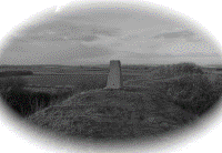
At the brow of the hill stop to admire the view: left to the old earthworks of Spetisbury Rings with its trig-point visible; to the East the Stour valley with Badbury Rings a prominent hump on the horizon about four miles away.
 Continue with the wood still on your right. At the end of the wood a copse border of high hedges remains on your right. At the end of the copse you have a wonderful view of the distant Purbeck Hills to the South. Turn 90 degrees to your right and follow down the field to a metal gate. Continue down through a second gate. A wide vista opens up to the West and North as the path descends to a third iron gate at the bottom of the field, opposite the west end of the commercial watercress beds.
Turn left along the tarmacked lane for about 80 metres to the footpath sign on your right. Cross the stile and walk diagonally left aiming for a stile in a gap in the hedge. Cross the stile and then follow the footpath signs which direct you sharp right along the edge of the field and over a further stile. Bear right through the field to a gap in the hedge with telephone wires above. Now aim for a stile NE and on the opposite side of the next field. Proceed diagonally on the worn track across the field towards the left of the farm buildings ahead. Cross the stile at this point and 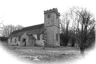 proceed down the lane to your left and under an old railway bridge reaching Hopegood Close in the village of Charlton Marshall. Turn right at Hopegood Close, past the playground and take the path back onto the Trailway. Turn left and follow the Trailway for about a mile until you get to the slope down from the Trailway by Spetisbury School. Take this exit and turn right at the road passing the schoool back to the A350. Cross over and go back to Marcia's Farm Shop Car Park.
Approximate Distance: 3 miles
Walk 4 - Middle Dairy Circuit
Dog owners please clean up after your dog and use the bins provided.
From Marcia's walk back to the road and cross the A350 walking straight ahead along the lane by the school. At the end of the school boundary turn left up the slope to the Trailway. At the top of the slope turn left along the Trailway going under the old railway bridge and continue about another quarter of a mile until you come to the old Spetisbury Halt Station. Go down the steps by the bridge at the side of the station.
Turn left up the lane, and after 100 metres turn left at the large metal gate signed to Spetisbury Rings. Follow the path up the field to the gap in the earthworks. At this point it is worth deviating slightly from the planned route by continuing on up to the trig point located at the top of the Rings, and spending some time enjoying the wonderful views in every direction including the Stour Valley, Bradbury Rings and the Purbeck Hills.
 Returning to the approach path at the top of the field, turn half right (facing the Rings) and make for the signpost at the gap in the hedge to your right. Follow the path diagonally across two fields, crossing two stiles (you cannot see the stile until you reach the rise in the field) leading to the buildings of Middle Farm Dairy where the signed path leads onto the tarmac lane.
Once on the lane turn sharp left and continue up a fairly steep hill and then down again until you come to a minor road, Louse Lane. Keep left down this road for about 100 metres and re-join the Trailway on your left. Take the Trailway past the station until reaching the slope by the school where you started the walk. Take this exit and turn right at the road passing the schoool back to the A350. Cross over and go back to Marcia's Farm Shop Car Park.
Approximate Distance: 3 miles
Walk 5 - Glebe Farm and Gorcombe Circuit
Dog owners please clean up after your dog and use the bins provided.
From Marcia's walk back to the road and cross the A350 walking straight ahead along the lane by the school. At the end of the school boundary turn left up the slope to the Trailway. At the top of the slope turn left along the Trailway. After approximately 200 meters turn right at the sign "FP10", and proceed over the wooden stile and then straight ahead with Home Plantation on your left. Go through a metal gate then diagonally across the field, passing houses on your right, to an iron gate at West End Lane, opposite the west end of the commercial watercress beds.
Turn left along the tarmac road and after approximately 80 metres turn right at the footpath signpost. Cross the field diagonally half-left, towards a gap in the thick hedge, at which point cross two stiles into a second field and continue diagonally towards a gate at the southwest edge of this field.
Go through the gate and turn right onto the farm lane and continue straight on, keeping the farm cottages and buildings to your right, until you come to two fields. Take the right hand field, and follow the left hand edge to a gate at the bottom of the field and dividing the hedge. The path continues across to the next farm track where you turn left. (Look out for lots of mud on the track, especially after any rain). Continue between the farm buildings and slightly uphill staying on the obvious track until it flattens out by a gate at the top of the incline. Go straight ahead on the marked track, taking care to ignore an unmarked but well worn farm track leading off to the left. Continue on the path until you reach Gorcombe farm. (This is an activity centre so be careful of quad bikes crossing in a couple of well-marked places. There is also a cafe serving drinks and snacks.) Continue past the farm, taking the tarmac road until it bends sharply right. Ahead of you is a path. As you approach it, you will find a second path which leads away to the left. Follow this path until you are walking downhill with a hedgerow on your left. At the end of this hedgerow, turn left at the metal gate and follow the footpath signs across a field with the solar farm on your left.Continue along this path until you reach North Farm.
At North Farm follow the West End Lane for about three quarters of a mile, back to the school and the main A350. Cross the road and back to Marcia's Farm Shop Car Park.
Approximate Distance: 4 Miles
The North Dorset Trailway
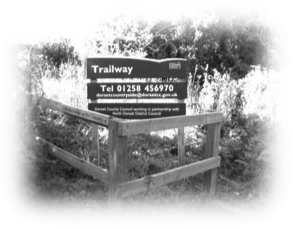

The Spetisbury to Blandford St Mary section of the "
The North Dorset Trailway" runs for 2.5 miles along a flat, surfaced, 2-metre wide track suitable for push chairs, horses, bicycles and walkers. The Spetisbury section starts at the East end of the village on Louse Lane, and passes alongside the Iron Age hill fort at Spetisbury Rings (well worth a detour) and the remains of Spetisbury Halt railway station, currently being restored by a group of enthusiastic volunteers -
see following link for details This section ends just short of the "Tesco" roundabout on the outskirts of Blandford Forum.
A leaflet is available to download via the following link showing all five sections of the Trailway currently open to the public, and stretching from Spetisbury to Sturminster Newton.